Lake Maps with Depths: Essential Bathymetric Tools for Effective Lake Management
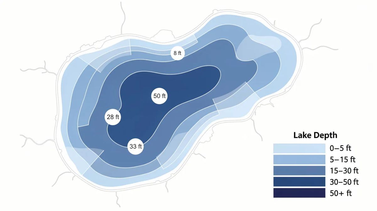
Lake maps with depths are vital resources for lake managers, anglers, and environmental consultants who need to understand, manage, and enjoy lakes and ponds. Bathymetric maps show the underwater topography of lake beds, similar to how topographic maps represent land features. These maps provide critical information for effective lake management, fishing, navigation, and environmental stewardship by revealing the underwater landscape that is otherwise hidden from view. Lake maps with depth details illustrate the underwater contours and depth variations of a body of water, making them indispensable for anyone involved in the stewardship or recreational use of lakes and ponds.
What Are Lake Maps with Depths (Bathymetric Maps)?
Lake maps with depths, also known as bathymetric maps, are specialized underwater topographic surveys that provide detailed depth contours illustrating the size, shape, and distribution of underwater features. These maps are essential for lake managers, anglers, environmental consultants, and anyone involved in the stewardship or recreational use of lakes and ponds. Bathymetric maps are crucial because they reveal the underwater landscape, enabling informed decisions for habitat management, fishing, regulatory compliance, and restoration projects.
Definition of Bathymetric Maps
Bathymetric maps provide detailed depth contours that illustrate the size, shape, and distribution of underwater features.
Definition of Contour Lines
Contour lines on a map connect points of equal depth; closer lines indicate a steeper drop-off while spaced lines indicate a gradual slope.
Lake maps with depth details illustrate the underwater contours and depth variations of a body of water.
Common Underwater Structures Identified on Maps:
- Points
- Humps
- Channels
Key elements of bathymetric maps include:
- Contour lines at 1-2 ft intervals
- Deep holes and shallow shelves
- Sediment deltas and inlet channels
With this foundational understanding, we can explore the different types of lake maps with custom depth shading and how they benefit various users, building on broader strategies for lake and wetland management.
Types of Lake Maps with Custom Depth Shading
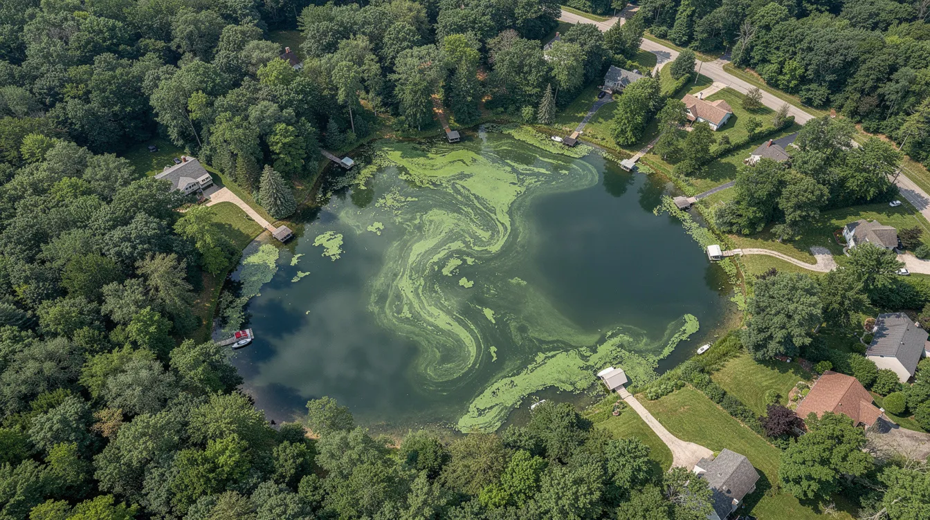
Lake maps come in a variety of formats, each designed to help anglers, lake managers, and recreational users make the most of their time on the water. These maps illustrate the underwater contours and depth variations of a lake or pond, including features such as humps, channels, and submerged islands—critical information for finding productive fishing spots and navigating safely. Whether you’re planning a fishing trip or managing a lake’s ecosystem, having access to accurate lake maps can make all the difference.
Digital Lake Maps
In today’s digital age, many lake maps and fishing data resources are available online. Many modern digital maps use color gradients to quickly convey the depth and shape of the lake basin. Modern digital maps use color shading to provide a three-dimensional visualization of the lake bottom. These digital lake maps are compatible with a variety of devices, including boats, fish finders, and GPS units.
Device Compatibility
Anglers can use these tools to pinpoint underwater features, mark fishing points, and share their favorite locations with others. The detailed information displayed on these maps—such as depth contours, humps, and structure locations—often uses color gradients and color shading to help users quickly view basin shape and bottom relief, respond to changing water conditions, and improve their fishing success. They can also highlight shallow bars, rocky reefs, and submerged islands for safer navigation.
Security Measures
To ensure a secure browsing experience, reputable websites employ robust security verification processes. This security service verifies that visitors are legitimate users and not malicious bots, protecting both the website and its valuable data. When you visit a site offering lake maps, you may encounter a brief waiting page while the security service verifies your access. Once verification is successful, you can explore a wide range of lake maps and fishing data tailored to regions across the USA.
Security measures like Ray ID and bot verification are essential for protecting websites from malicious activity. By ensuring that only human users can access sensitive mapping data, these services maintain the integrity of the site and the safety of its users. This means you can confidently use and share lake maps, knowing your experience is protected.
Ultimately, the combination of advanced lake mapping and strong security verification allows anglers and lake managers to find, use, and share detailed underwater data with confidence. Many mapping services also include high-resolution bathymetric data, vegetation layers, and custom depth shading to improve fishing success and navigation. Whether you’re searching for the next great fishing spot or managing a lake’s health, secure access to accurate lake maps is an invaluable resource.
As you explore the types of lake maps available, understanding the mapping process itself will help you appreciate how these maps are created and applied.
Lake and Pond Mapping
Lake and pond mapping is an essential tool for understanding and managing freshwater bodies. This process is especially valuable for lake managers, anglers, and environmental consultants who rely on accurate lake maps with depths to make informed decisions within sustainable lake management practices. The mapping process involves creating detailed representations of underwater features, depth contours, and the overall shape of the water body.
Technologies Used
- GPS
- Sonar
- GIS (Geographic Information Systems)
Applications
- Environmental monitoring
- Habitat assessment
- Resource management
Benefits
- Identifies critical areas for professional plant and algae management services, invasive species management, and aeration system placement
- Supports regulatory compliance by providing precise volume and depth information required by environmental agencies and aligning with professional lake consulting and management in Northern NJ and Upstate NY
- Empowers lake communities to make informed decisions about restoration projects and ongoing maintenance
By integrating lake mapping into management practices, lake owners and managers in regions such as northern New Jersey and upstate New York can enhance water quality, protect aquatic ecosystems, and optimize recreational use of their water bodies.
Now that we've covered the mapping process, let's highlight the most important takeaways for effective lake management.
Key Takeaways
- Lake maps with depths (bathymetric maps) reveal underwater features like contours, humps, and basin shapes essential for managing algae, invasive species, and water quality in Northern New Jersey, New York, Vermont, and Ontario.
- Ready Scout, LLC’s professional lake consulting and management services use professional depth mapping, permitting & regulatory compliance, plant & algae management, water quality monitoring & lake mapping, aeration system design & installation, invasive species control, and lake community self-sufficiency consulting.
- Modern surveys combine GPS, sonar, and GIS to create accurate data far superior to generic fishing apps or outdated charts, supporting customized water quality monitoring and lake mapping services.
- Precise volume calculations from depth maps can reduce chemical use by 10-25% while improving treatment efficacy.
With these key points in mind, let’s look at where you can obtain reliable lake maps with depths for your specific needs.
Why Accurate Depth Maps Matter for Lake Management
Depth mapping is typically the first step in any serious management plan. Here’s why:
- Algae & Weed Control: Target treatment zones and calculate acre-feet precisely.
- Water Quality: Identify stratification zones that trap phosphorus.
- Invasive Species: Map depth bands where milfoil (3-12 ft) or water chestnut thrives.
- Aeration Design: Position diffusers at basin lows for optimal circulation.
- Permitting: Provide volume data regulators require.
Understanding the importance of depth maps sets the stage for learning how these maps are created with modern technology.
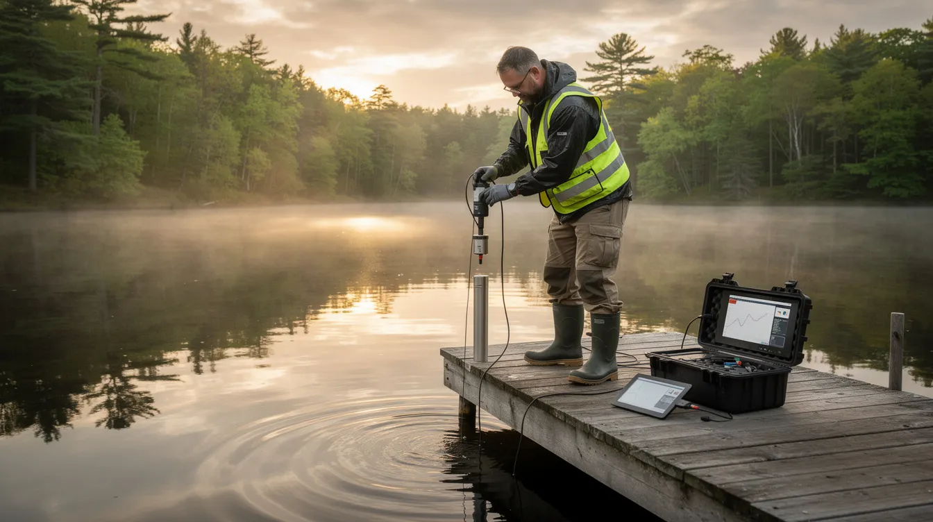
How Lake Depth Maps Are Created Today
Survey Process
Modern surveys use boat-mounted sonar with GPS to log depths along systematic transects. Ready Scout processes this data through GIS software, creating continuous contour maps that protect the accuracy needed for compliance.
This approach verifies conditions far better than crowdsourced apps, which lack the details and metadata agencies require.
With a clear picture of how depth maps are created, let’s see how they are used for practical lake management and fishing applications.
Using Depth Maps for Algae, Plants, Invasive Species Management, and Fishing Spots
Overlaying Plant Data
Ready Scout overlays plant survey data on depth contours to find exactly where problems occur. Treatment polygons are drawn directly on maps to calculate precise dosing—critical for regulatory compliance across the USA and Ontario and supported by accessible aquatic product label information and expert lake consulting and management.
Fishing Spots
Detailed lake maps with depths reveal underwater structures such as humps, channels, and drop-offs that are prime fishing spots. Anglers can use these maps to target specific areas where fish are likely to gather.
By leveraging these applications, lake managers and anglers can maximize the benefits of depth maps for both ecological health and recreational success, especially when integrating water quality monitoring and lake mapping services.
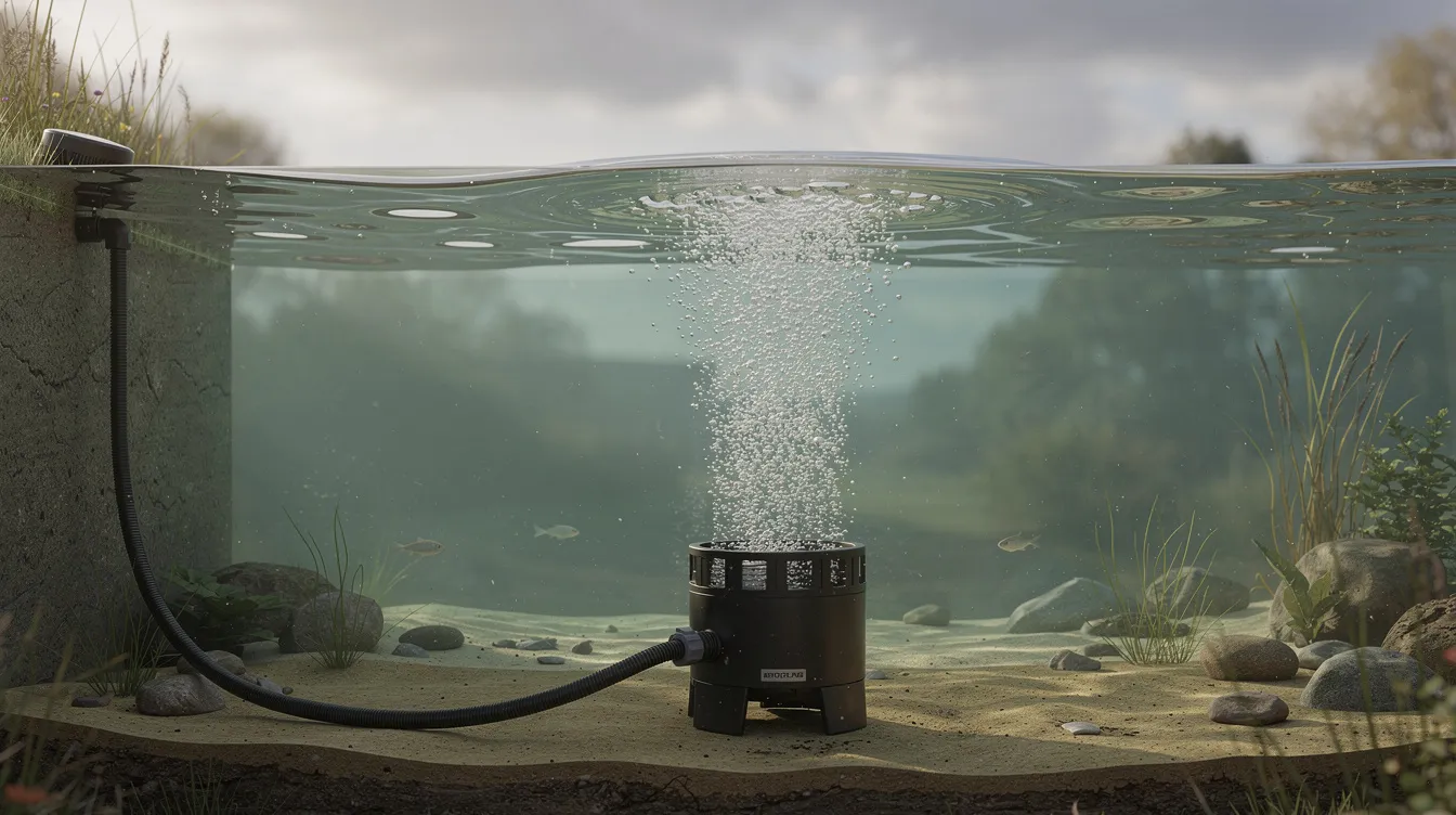
Designing Aeration Systems and Restoration Projects
Aeration System Design Steps
Without depth data, aeration design is guesswork. Ready Scout uses bathymetry to:
- Locate diffusers at basin low points
- Size compressors based on actual volume
- Plan dredging by tracking sediment accumulation
- With accurate bathymetric data, restoration and aeration projects can be planned and executed with confidence, especially when paired with professional aeration system design and installation.
Regulatory Compliance and Permitting
Permitting Requirements
Agencies in NJ, NY, VT, and Ontario require depth/volume data for pesticide permits, dredging approvals, and dam inspections. Ready Scout’s permitting & regulatory compliance service prepares mapping reports that reduce back-and-forth with regulators.
Accurate mapping streamlines the permitting process and ensures compliance with all regulatory requirements, particularly when supported by specialized permitting and regulatory compliance services.
How Are Lake Maps with Depths Used for Fishing, Navigation, and Lake Management?
Lake maps with depths are invaluable for fishing, navigation, and lake management because they:
- Illustrate the underwater contours and depth variations of a body of water, helping users identify productive fishing spots, safe navigation routes, and critical habitat zones.
- Show the underwater topography of lake beds, similar to how topographic maps represent land features, providing a clear picture of the lake’s structure.
- Use color gradients and shading in modern digital maps to quickly convey the depth and shape of the lake basin, offering a three-dimensional visualization of the lake bottom.
- Offer precise 1-foot contour detail for over 24,000 lakes in the U.S. and Canada through C-MAP Genesis charts, revolutionizing freshwater fishing with user-generated data.
- Include features like high-resolution bathymetric data, custom depth shading, and vegetation layers in mapping services to enhance navigation and fishing success.
How Ready Scout Supports Lake Communities
Community Training and Support
Ready Scout, LLC serves lake associations, municipal parks, and private estates across the region with integrated services built on accurate bathymetry. Our lake community self-sufficiency consulting and broader lake community self-sufficiency assessments train volunteers to read contours and track outcomes independently.
Consider a baseline survey as a one-time investment supporting 5-10 years of management decisions, guided by an experienced principal Certified Lake Manager. Share your needs with Ready Scout to get started.
Frequently Asked Questions About Lake Maps with Depths
How often should a lake be remapped?
Stable lakes need resurveying every 5-10 years. Stormwater ponds receiving heavy runoff may warrant updates every 3-5 years, especially after major floods or dredging.
Can we use free online bathymetric data?
Public datasets are often coarse or outdated. For precise volumes and regulatory submissions, site-specific surveys are recommended. Just like website security verification protects against malicious bots, professional mapping protects your management decisions from bad data.
Does ice cover affect survey timing?
Most surveys occur April-November during ice-free periods. Ready Scout schedules fieldwork around regional ice-out timing in NY, VT, and Ontario. Rather than waiting for problems, page through your calendar and plan surveys early in the season when verification successful conditions exist.
What equipment is used to create lake depth maps?
Modern lake mapping uses boat-mounted sonar combined with GPS technology to gather accurate depth data along systematic transects. This data is processed with GIS software to create detailed contour maps showing underwater features and volume.
Can lake depth maps help improve fishing success?
Yes, detailed lake maps with depths reveal underwater structures such as humps, channels, and drop-offs that are prime fishing spots. Anglers can use these maps to target specific areas where fish are likely to gather.
Are lake depth maps accessible on mobile devices?
Many lake depth maps can be downloaded and used offline on portable devices, allowing users to access detailed underwater terrain information even without internet connectivity while on the water.